December 15, 2023
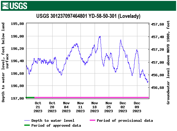
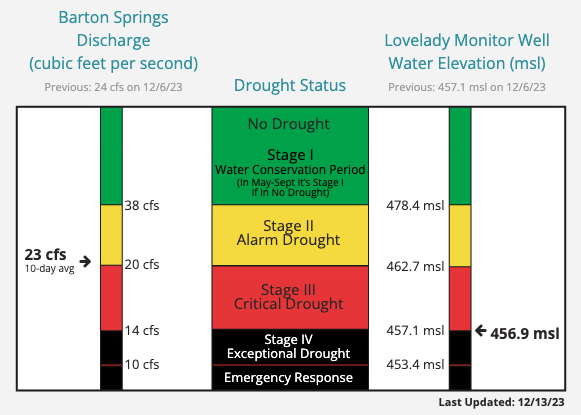
Barton Springs/Edwards Aquifer Conservation District (the District) officially declared Stage IV Exceptional Drought on December 14, 2023 for the first time in their 36-year history. Stage IV declaration restrictions will take effect on January 1, 2024. This transition is a result of the Lovelady monitor well, one of two drought trigger determinants, reaching a 10-day average of 456.9 feet-mean sea level (ft-msl). This is below the District’s 457.1 ft-msl threshold for Stage IV. For reference, the average water level elevation for Lovelady monitor well since measurements began in 1949 is 492.8 ft-msl. (For additional information on the Lovelady monitor well, view this article.)

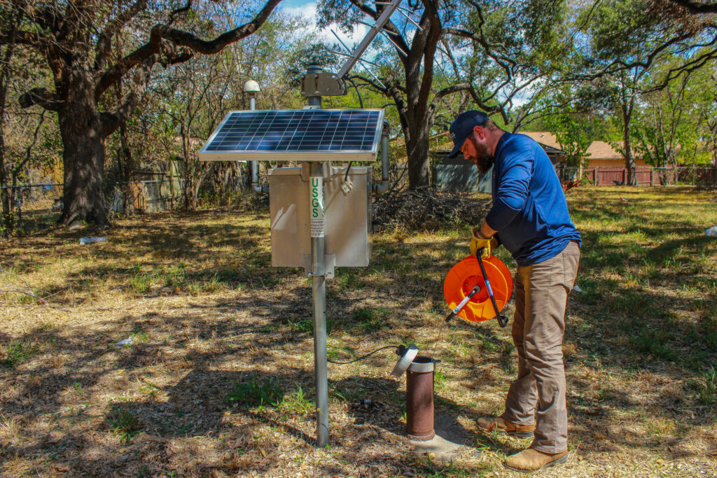
Lovelady monitor well data obtained by USGS automatic gauge.
This decline is representative of the alarmingly low water levels of the Barton Springs segment of the Edwards Aquifer, which serves as a drinking water source for over 60,000 people from south Austin to northern Kyle and is overseen and managed by the District.
Prior to entering Stage IV, the District had been in Stage III Critical Drought since October 2022 when the Lovelady monitor well initially crossed the drought threshold. Lovelady groundwater levels and Barton Springs flow serve as the determinants for the District’s current drought stage. Only one of these sites needs to cross a new drought threshold for a District declaration to be made. However, to exit a stage, both Barton Springs and Lovelady must both rise above their respective drought threshold values.
Stage IV drought requires 30-100 percent reduction in pumpage by the District’s 149 permittees, which vary in size from individual well owners to larger water service providers like the cities of Buda, Kyle, Hays, and Sunset Valley. Permittees will experience various degrees of restrictions based on their classification, and those who don’t meet these restrictions are subject to monthly drought penalties. While the District doesn’t enforce restrictions on end users served by water utilities on groundwater wells, such as Creedmoor Maha Water Corp, Goforth Special Utility District, and Texas Water Utilities, it is up to the permittee to ensure reductions are met. Water utility customers can contact their service provider for additional information.
The only way for groundwater resources to recover and end these drought conditions is a long period of widespread and significant rainfall over local aquifer recharge zones. Until this occurs, community members in and outside of the District can do their part by actively conserving water resources to minimize surface and groundwater depletion to help our aquifer levels recover. Groundwater use should be limited to essential indoor demands with little to no water allocated for outdoor purposes.

The District’s drought chart displaying Barton Springs flow, Lovelady monitor well groundwater level, and District drought thresholds for both.
Barton Springs/Edwards Aquifer Conservation District is a groundwater conservation district charged by the Texas Legislature to work with well owners to conserve and protect the Edwards and Trinity aquifers and groundwater resources within its territory. The District covers 430 square miles in parts of Travis, Hays, and Caldwell counties; home to about 400,000 people. For additional information, visit www.bseacd.org or call 512-282-8441. [source: https://bseacd.org/2023/12/stageivdrought/?eType=EmailBlastContent&eId=721d5a89-8a9f-485f-854d-122ffc5d0a5a]

